Trusted. Independent. Local.eric@cornerstoneappraisal-az.com

Phoenix Appraisal Blog / Neighborhood insight

The neighborhoods that shaped Phoenix

· Neighborhood insight

Historic Phoenix neighborhoods: Eight places with a story

A short walk can take you from a turn-of-the-century street grid to a garden suburb. Explore eight historic districts and the different stories their homes tell.

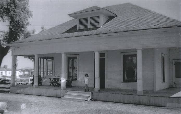
Archival black-and-white photograph of a broad-porch house with a child at the front steps
Historic broad-porch home; location and date have not been verified.
TL;DR

Phoenix has 36 designated residential historic districts. This tour spotlights eight of them, from Willo and Encanto–Palmcroft to Coronado and Garfield. Their street plans, architecture and preservation efforts tell different chapters of the city’s growth. A future installment could explore another eight districts.

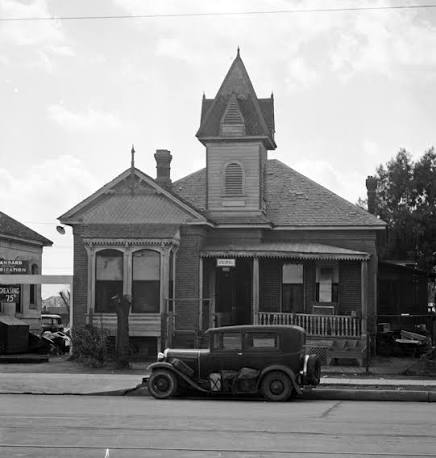
Archival black-and-white photograph of a steep-roofed historic house with a front porch and an early automobile
Historic home with a tower and porch; location and date have not been verified.
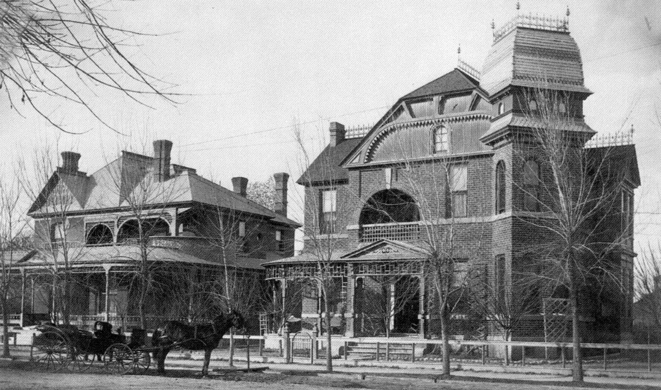
Archival black-and-white photograph of Millionaires’ Row along Monroe Street in Phoenix during the 1890s
Millionaires’ Row along Monroe Street in the 1890s.

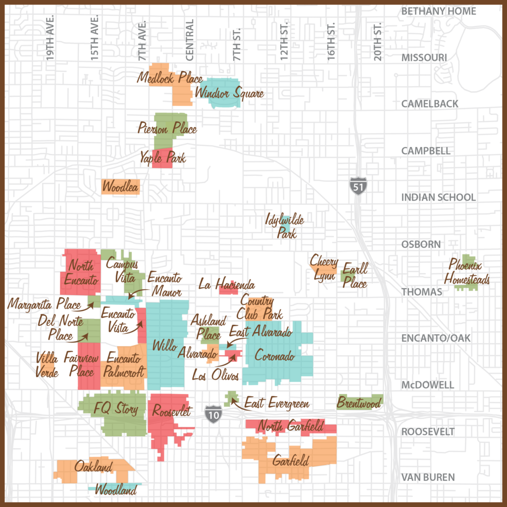
Click a district on the map

Select a numbered marker for a neighborhood story. Each of the eight districts opens an illustrated profile with its own expandable historic map. Markers are approximate orientation points, so consult official district maps for exact boundaries.

Map of the 36 Phoenix residential historic districts, with colored areas and labels; numbered buttons identify the eight districts featured in this tour

Choose a map marker to explore the neighborhood’s history.

How the neighborhood stories differ

1. Willo

From speculative bungalows of the 1920s to Period Revival homes and later Ranch designs, Willo shows how central Phoenix grew.

2. Encanto–Palmcroft

Curving streets, palms, detailed revival homes and neighboring Encanto Park turn these two subdivisions into a garden suburb.

3. F.Q. Story

Period revival homes, a freeway dividing its streets, and the neighbors who organized to preserve them.

4. Roosevelt

Grand early homes, bungalow lined streets and a neighborhood shaped by Phoenix’s streetcars and downtown revival.

5. Coronado

From a 1908 subdivision to bungalows, period revival cottages and the neighborhood’s 1939 tract homes.

6. Garfield

An 1883 farm subdivision grew into a streetcar neighborhood of porches, bungalows, small stores and later ranch homes.

7. Windsor Square

A curvilinear 1929 subdivision whose completion was interrupted first by the Depression and then by World War II.

8. Del Norte Place

Opened in 1927 and later shaped by Depression-era construction and its setting beside Encanto Park.

Why these districts matter

These neighborhoods preserve more than individual houses. Their streets, setbacks, landscaping and mix of architectural styles show the choices Phoenix residents and builders made as the city grew. Local designation can help protect that character. The map is an introduction to the places and their history, not a parcel-level boundary or property-status determination.

Sources & map notes

Phoenix Historic Neighborhoods Coalition provides neighborhood context. Windsor Square Historic Neighborhood supports the Windsor Square profile and development chronology. The Willo Neighborhood Association and historic preservation history of Willo support its profile; Encanto–Palmcroft’s preservation association and historic preservation account support the second; F.Q. Story’s association history supports the third; Roosevelt’s neighborhood association history supports the fourth; Coronado’s preservation history supports the fifth; Garfield’s district history supports the sixth. The overview map shows schematic locations, not legal district outlines. The Del Norte Place profile draws on the neighborhood history supplied for this tour and the City of Phoenix historic-district map.

More from Cornerstone Appraisal

Explore the Phoenix Appraisal Blog archive for housing and appraisal insights.

A visual history of the Salt River Valley

How Phoenix became a city

Canals, a townsite, railroads, neighborhood growth and the modern metropolis.

Before 1867

The valley before Phoenix

People lived along the Salt and Gila Rivers long before a city called Phoenix appeared. The area’s ancestral Indigenous farmers engineered canals that carried river water into fields and supported a network of settlements. Their waterworks belong at the beginning of the story: the canal landscape later influenced where newcomers would farm and build.

The City of Phoenix’s S’edav Va’aki Museum preserves a portion of that history and describes the canal system as among the most sophisticated in the pre-European Americas. Indigenous history did not end when old settlements changed; O’odham and Piipaash communities remain part of the Valley. Exact dates and explanations for changes in ancient settlements remain subjects of study, so this tour does not present a single event as the reason they changed.

The first Phoenix story is a story of water and people. Modern streets and historic houses were built on a landscape shaped long before the nineteenth century.

1867–1889

Canals, homesteads and a townsite

In 1867 Jack Swilling and other settlers organized an irrigation venture to divert Salt River water to farm fields. According to the City of Phoenix history, the new canal carried water by March 1868. A small settlement took shape, and the name Phoenix came to express the idea of a new community rising near the remains of an older canal civilization.

Retrospective homestead sketch showing early Salt River Valley entries; the image is not a surveyed Phoenix street map from 1867.

A post office opened in 1868. Surveyors laid out a townsite in 1870, and lots went on sale that December. The downtown street grid became the core around which later neighborhoods formed: Central Avenue separates numbered streets to the east from numbered avenues to the west. Phoenix incorporated on February 25, 1881, with roughly 2,500 residents. Rail service reached the city in the late 1880s, making it easier to bring in goods and ship crops; Phoenix became Arizona’s territorial capital in 1889.

Bird’s-eye depiction of Phoenix around 1885; a promotional view rather than a measured boundary map.

1890s–1930s

Rails, reclamation and the first residential rings

Horse-drawn streetcars arrived in 1887; electric cars replaced them in the 1890s. Rail connections, new businesses and government offices strengthened downtown. The Roosevelt Dam, dedicated in 1911, supplied a more controlled water source for agriculture and new development. Arizona became a state in 1912. Phoenix was growing beyond its original townsite, and builders began filling blocks north and east of downtown with bungalows and later Period Revival homes.

By 1920 Phoenix had about 29,000 residents, according to the city’s historical account; the 1930 count was 48,118. Early electric streetcar corridors, paved streets and growing automobile ownership affected where families could live. Developers marketed tree-lined subdivisions and varied architectural styles: English cottages, Tudors, Spanish Colonial Revival homes and modest bungalows all appeared in the districts featured on this page.

The Depression slowed many developments, leaving some subdivisions to be completed over years rather than one building campaign. Federal mortgage programs, new construction methods and later wartime constraints changed the size and look of houses built in the 1930s and 1940s. That layered history explains why a single historic district may contain several distinct building eras.

1940s–1960s

From farm center to fast-growing metropolis

During World War II, military training fields and new industry brought workers and service members into the Valley. Many returned after the war with families. Phoenix expanded quickly through house building, jobs, improved transportation and technologies that made year-round desert life more practical. The city’s history records roughly 105,000 residents in 1950, more than twice its 1930 population.

Phoenix street map from approximately 1949. Compare the downtown grid with later growth.

Residential design changed with that growth. Ranch houses spread across wider lots, garages became more prominent and newer roads carried development beyond the early streetcar neighborhoods. Downtown changed, too, as offices, civic buildings and a larger road network grew alongside the housing stock.

1970s–today

Remembering old Phoenix while planning its future

Phoenix grew into a metropolitan center stretching far beyond the 1870 townsite. Highway construction, new housing and downtown redevelopment altered many older areas. Residents in neighborhoods such as F.Q. Story, Willo and Coronado organized to keep their streets and architecture legible as the city changed. The eight profiles in this tour show what survived, what was adapted and why neighborhood preservation matters.

Modern Phoenix-area road map. Road lines show how far the metropolitan network extends beyond the original townsite.

Water remains central to the city’s future. In 2023, the Arizona Department of Water Resources reported that its Phoenix-area groundwater model could not support new approvals for certain subdivisions relying solely on groundwater under the 100-year assured-water-supply rules. That finding concerned a particular source of water and approval process; it was not a halt to all homebuilding throughout Phoenix. It is a modern echo of an old fact: where and how Phoenix grows depends on how it secures and manages water.

Back to the neighborhoods: the larger city grew around these streets, but their porches, setbacks, trees and varied rooflines still let visitors see distinct chapters of Phoenix history.

Sources and image notes: City of Phoenix history; S’edav Va’aki Museum; ASU Kyl Center analysis of the 2023 groundwater model. Photo dates are approximate where original archival dates could not be confirmed. The historical maps are illustrations or period references, not current parcel maps.

The neighborhood collection · 01

Willo Historic District

Central Phoenix · circa 1920s–1940s

Willo began on the agricultural edge of a growing city. Its homes, street patterns and preservation efforts now tell a century-long story about the making of central Phoenix.

LocationThomas Road to McDowell Road; Central Avenue to 7th Avenue
Historic fabricMore than 700 homes in 17 subdivisions
Local designation1990 historic district

A planned place, built in stages

Willo’s early tracts were once farmland at the edge of Phoenix. From 1920 to 1925, a company called Home Builders put up 41 bungalows and marketed them with an installment-payment plan. Building a group of homes at once helped prospective buyers picture an established community where there had been open land.

As Phoenix expanded in the late 1920s, other developers sold lots in larger subdivisions. North Kenilworth and Broadmoor were platted in 1928. Broadmoor’s curving streets show the era’s interest in planned and visually distinctive neighborhoods. A furnished “Spanish Rancho Home” served as an exhibition house: visitors could see its design and modern systems before purchasing nearby lots.

Building covenants and minimum construction costs shaped the homes and the people who could buy them. Some historic covenants also restricted buyers by race. That exclusion is part of Willo’s history and should be acknowledged alongside the district’s architecture and planning.

Phoenix adopted its first zoning ordinance in 1930, establishing land-use rules across the growing city. Construction slowed during the Depression, then federal mortgage insurance and design standards influenced later development. Willo’s 1986 conservation plan and its 1990 local historic designation reflect a later chapter: residents organizing to protect neighborhood character.

Phoenix Historic Property Register district map (December 2006). The shaded parcels show the mapped historic area; the road descriptions are a general location guide.

A walk through the architecture

Bungalow & CraftsmanOften one story, with broad overhangs and a welcoming porch; wood, brick and stucco appear across the district.
Tudor & Cotswold RevivalSteeper roofs, prominent gables and decorative half-timbering; Cotswold variations evoke a curved, thatched roof.
Spanish Colonial & Mission RevivalStucco walls, arches, red tile and a low horizontal silhouette influenced many 1920s homes.
Later homesStreamlined Period Revival forms and Ranch-style houses trace the neighborhood’s growth into the mid-twentieth century.
On the home tour: Look for shifts in roof shape, porch design and street layout as the neighborhood moves from early bungalows to later Period Revival and Ranch-style homes. The uploaded district map helps connect those building eras to Willo’s streets.

Willo’s neighborhood association typically holds its annual home tour on the second Sunday in February; check the association for the current date and participating homes.

Sources: Willo Neighborhood Association (location, architecture and tour); City of Phoenix Historic Preservation Office brochure reproduced by HistoricPhoenix (development, styles, conservation and designation). Images and district-map screenshot supplied by the blog owner; individual photo addresses have not been verified.

The neighborhood collection · 02

Encanto–Palmcroft

Central Phoenix · 1927–1942

These two planned subdivisions trade Phoenix’s regular street grid for curved drives, generous setbacks and landscaped streets. Their proximity to Encanto Park ties the homes to a larger vision of a garden suburb.

SettingWest of 7th Avenue, between McDowell Road and Encanto Park; see mapped district limits
Building eraPrimarily 1927–1942, with later homes and alterations
Local designationHistoric district listed by Phoenix in 1987, with later boundary changes

Two plans, one neighborhood

Dwight B. Heard’s investment company began Palmcroft on land north of McDowell Road. Heard, planning advocate William G. Hartranft and surveyor Harry E. Jones shaped a development that paired curving streets with palms, lighting and other modern utilities. The first plat was filed in 1927; a second Palmcroft section followed in 1929. Model homes helped establish a design standard before many of the surrounding lots were built.

North of Palmcroft, businessmen Lloyd C. Lakin and George T. Peter planned Encanto with Jones’s help. Their 1928 plan carried the same attention to curving streets and landscape, while providing an underground irrigation system. Early homes appeared around its eastern circle. The Depression slowed completion of the western section, so the district records both 1920s optimism and the interrupted pace of 1930s building.

The city acquired land for Encanto Park beginning in 1934. Built with New Deal-era public works assistance and completed in the late 1930s, the park’s lagoon, groves and winding paths extend the neighborhood’s landscape ideas into public space. Seen together, homes, streets and park explain why the district is valued for its overall plan as well as individual architecture.

City of Phoenix Historic Property Register map (November 2005). The shaded blocks show the district mapped at that date. Use current city records for parcel-level boundaries.

Architecture along the curves

Period Revival styles give the streets their variety. Spanish Colonial Revival and Mediterranean houses frequently use stucco, arches and tile roofs. Monterey Revival combines Spanish and American traditions, often with a second-story porch. Tudor Revival brings sharper gables and textured wall details; Pueblo Revival takes cues from adobe forms, flat roofs and projecting timber vigas. Later Ranch houses add another layer of the district’s history.

Spanish Colonial & MediterraneanStucco surfaces, arched openings, red tile and asymmetrical massing.
Monterey RevivalOften a two-story form with a prominent upper porch.
Tudor RevivalSteep gables and a picturesque roofline give each façade a distinct outline.
Pueblo Revival & RanchRegional forms and later low, horizontal houses mark changing eras.
Next home tour: The Encanto–Palmcroft Historic Preservation Association lists its centennial Historic Home Tour & Street Fair for Sunday, March 14, 2027, 9 a.m.–4 p.m. Event plans can change; check the association’s event page before visiting. The tour is described as occurring every other year by Visit Phoenix.

Sources: Encanto–Palmcroft Historic Preservation Association (neighborhood history, architecture and park); City of Phoenix preservation narrative reproduced by HistoricPhoenix (developers, street planning and building eras); 2027 association event notice. District map and home images were supplied by the blog owner. Current district boundaries should be checked against city records for a particular property.

The neighborhood collection · 03

F.Q. Story

Central Phoenix · platted 1920

A neighborhood of varied early twentieth-century houses survived a dramatic change to its street map. F.Q. Story’s preservation story is as much about neighbors organizing as it is about architecture.

LocationMcDowell Road to Roosevelt Street; 7th Avenue on the east, 17th Avenue and Grand Avenue along the west
Historic period1921–1942; homes also built beyond those years
NeighborhoodAbout 602 homes, according to the Story Preservation Association

From farmland to streets

Francis Quarles Story, a Boston-born businessman with investments in California citrus and the Southwest, lent his name to the subdivision platted in 1920. As Phoenix grew, homebuilding filled the streets over the following decades. The resulting neighborhood did not follow one house pattern: modest bungalows sit near larger homes with European or Southwestern influences.

What to look for

Craftsman bungalowsBroad porches, low roofs, overhanging eaves and visible woodwork.
Spanish Colonial & Pueblo RevivalStucco walls, arches and Southwestern forms; details vary by house.
English TudorSteep gables, prominent chimneys and sometimes brick or textured masonry.
Transitional RanchLower, simpler forms that point toward the city’s midcentury building patterns.

A freeway through the neighborhood

After World War II, development shifted outward and many older central-city homes faced neglect or demolition. Plans for the Papago Freeway—today’s Interstate 10—then placed F.Q. Story in the route. Houses were removed or relocated, blocks disappeared, and the corridor ultimately separated the neighborhood’s north and south sections. Look at the map: the freeway crosses right through the district.

Neighbors write the next chapter

Residents met in June 1984 to discuss conservation and neighborhood protection. By July they were organizing around security, zoning and the freeway; on July 11 they chose the name Story Preservation Association. They pursued a historic-resource survey and preservation work. The neighborhood was listed on the National Register of Historic Places in 1988. The association’s home tour, begun in 1985, has helped fund and celebrate that continuing work.

City of Phoenix Historic Preservation Office map, updated November 2016. Use + and − in the enlarged view.
Visit the neighborhood. The association’s 2026 Home & Garden Tour is scheduled for Saturday, December 5, 2026. Check the organizer for event updates.

Four views of Story

Sources: Story Preservation Association neighborhood history (platting, freeway, organizing, home tour and designation); association overview (number of homes, styles and bounds); 2026 Home & Garden Tour (event date). District map and photographs supplied by the blog owner; individual photo addresses have not been verified.

The neighborhood collection · 04

Roosevelt Historic District

Downtown Phoenix · a streetcar suburb grows

Roosevelt preserves a chapter of Phoenix’s growth north from the original townsite. Its homes range from large residences built for early civic and business leaders to welcoming bungalows; today historic houses and new urban life share the same walkable streets.

Historic mapGenerally McDowell Road to Fillmore Street, between 7th Avenue (west) and Central Avenue (east); boundaries vary by block
DevelopmentCity expansion into the area began in the 1890s; much of the historic housing followed through the 1920s
RecognitionPhoenix’s first designated historic neighborhood; National Register listing in 1983

A northward move

Phoenix’s first townsite lay farther south. As the city grew in the late nineteenth century, families and professionals moved northward. Better building materials arriving by rail, Central Avenue’s prominence and the streetcar lines all helped shape Roosevelt. By statehood in 1912, homes for doctors, attorneys, businesspeople and public leaders were already part of the district’s streetscape.

New development continued across multiple additions rather than one uniform plan. Kenilworth School, completed in 1920, became a neighborhood anchor. Moreland and Portland Parkways show how generous landscaping and shaded streets also influenced the district’s character.

Read the houses

California & Craftsman bungalowsBroad porches, shaded overhangs, exposed details and practical floor plans.
Period revival homesSpanish Colonial, Mission and English Cottage forms join other early twentieth-century styles.
Older detailsLook for surviving porches, original window patterns, masonry and established trees.
A varied scaleGrand houses, smaller homes and later adaptations reflect generations of residents and uses.

From homes to a mixed-use district

As downtown changed, some large houses became offices or other uses, especially near government and commercial activity. The 1925 Gold Spot shopping center at 3rd Avenue and Roosevelt Street is an early example of shops planned for neighborhood customers. The threatened freeway, suburban growth and redevelopment later put pressure on older buildings. Preservation advocates helped secure Roosevelt’s National Register listing in 1983.

Arts on the doorstep

The surrounding downtown district has again drawn residents, businesses and visitors. Roosevelt Row and its First Friday art walk lie nearby, especially east of Central Avenue; they are part of the wider Roosevelt-area experience, not the same thing as every block shaded on the historic district map.

City of Phoenix Historic Preservation Office map, April 2005. Shaded parcels show an irregular district boundary; click for a closer view.
Walk through history. The Roosevelt Neighborhood Home Tour is scheduled for Saturday, November 14, 2026, 10 a.m.–4 p.m. Check the organizer for updates.

Four views of Roosevelt

Sources: Roosevelt Action Association history (early growth, architecture, landmarks, preservation and nearby arts); Roosevelt Action Association event page (2026 tour). City of Phoenix historic district map and photographs supplied by the blog owner; individual photo addresses have not been verified.

The neighborhood collection · 05

Coronado Historic District

Central Phoenix · from streetcar suburb to neighborhood landmark

Coronado is a portrait of how ordinary Phoenix families made a new neighborhood in the early twentieth century. Its western bungalow blocks and later eastern cottages and ranch homes tell two connected chapters of the city’s growth.

WhereGenerally Virginia Avenue to Coronado Road or McDowell Road, between 7th Street and roughly 14th–16th Streets; use the mapped blocks for exact limits
Building erasInitial plats in the 1900s; extensive construction in the 1920s and again in the late 1930s–1940s
City listingHistoric district listed November 1986; supplied City of Phoenix map updated November 2016

Land and opportunity

At the start of the century, investors expected a growing Phoenix to need new residential land. Dwight B. Heard’s Suburban Realty Company petitioned in 1908 to divide land between 7th and 12th Streets near McDowell Road and the former canal along Oak Street. Homewood Tract, Syndicate Place and Rancheros Bonitos were among the early additions that later became Coronado.

Developers initially imagined a prestigious streetcar suburb, but Coronado’s location farther east of Central Avenue encouraged smaller and more affordable houses. Rather than one architect’s master plan, the district grew through a mixture of subdivision plats, builders and household needs.

Families make a neighborhood

After World War I, speculative builders put up houses on whole blocks in anticipation of buyers. Workers in retail, offices, city services, railroads and other occupations moved in. The Brill Street trolley extension, nearby hospital, Emerson School and Coronado Park helped make the area useful for growing families. The park remains a neighborhood gathering place.

A change in building styles

Bungalows, especially westBroad front porches, low rooflines and practical one-story layouts mark many 1920s blocks.
Spanish Colonial RevivalStucco, arches and other period details appear throughout the district.
Tudor & English CottageSteep gables and picturesque details are especially visible in later eastern blocks.
Later ranch formsSimpler, lower houses track the 1930s and 1940s shift in Phoenix design.

Adaptation and recovery

Construction slowed during the Depression. Some residents converted garages or built separate living quarters to help keep their properties; each surviving structure has its own legal and construction history. In 1939 Andy Womack built a planned subdivision between Monte Vista and Palm Lane near 13th and 14th Streets, an early step toward the tract-building methods that would later become common across the Valley. The mix of old and new homes gives Coronado its varied streetscape today.

City of Phoenix Historic Preservation Office map, updated November 2016. Highlighted parcels, rather than the general street ranges, show the registered district.
Tour the neighborhood. The Coronado Neighborhood Association hosts an annual Historically Modern Home Tour and Street Fair. Its 2026 event was February 22; check the association for the next date.

Four views of Coronado

Sources: Phoenix Historic Preservation history reproduced by Historic Phoenix (subdivisions, transit, architecture, Womack and neighborhood development); Coronado Neighborhood Association (home-tour tradition and 2026 event). City historic district map and four photographs supplied by the blog owner; individual photo addresses have not been verified.

The neighborhood collection · 06

Garfield Historic District

East of downtown · an early addition to Phoenix

Long before Garfield’s bungalow streets took shape, this land was an irrigated farm at the edge of Phoenix. Its transition from fields to city blocks makes the neighborhood a readable history of how Phoenix grew east of downtown.

NeighborhoodBroadly 7th to 16th Streets, between Van Buren Street and I-10; includes Garfield and North Garfield
Mapped districtThe City’s Garfield map highlights an irregular area primarily south of Roosevelt Street; North Garfield is a separately designated area to the north
GrowthDennis Addition platted in 1883; most surviving housing dates to the early twentieth-century building boom

From the townsite to Dennis Addition

The 1870 Phoenix townsite ended at Van Buren Street. Farmer John T. Dennis held land just beyond its northeastern edge, from 7th to 12th Streets and north toward Roosevelt Street. In 1883 he platted his former farm as the Dennis Addition, preserving a street grid that connected the new blocks to the young city. Other owners subdivided the larger tracts into residential lots over the following decades.

The earliest homes were relatively few and scattered. The 1893 Burgess Hadsell House on East Fillmore Street is among the area’s surviving reminders of that first period. Larger growth came as streetcar access, irrigation, population gains and later automobile travel made the neighborhood practical for more households.

Porches fill the blocks

By the 1910s and 1920s, Garfield had become a neighborhood of modest homes built by many different builders. Craftsman and California bungalows were common: shaded porches, broad roof overhangs, exposed rafters and posts on masonry piers made the streets feel connected even when no two houses were identical. Streetcar routes helped early western blocks grow; the opening of eastern lots followed as residents increasingly used automobiles.

Layers of architecture

Early cottagesSome older brick and wood houses, including hipped and pyramidal roof cottages, predate the bungalow boom.
Craftsman bungalowsPorches, eaves and practical plans define many of Garfield’s most recognizable streets.
Period revival detailsSpanish Colonial Revival arches and stucco sit alongside some Tudor and English Cottage forms.
Ranch era infillLower rooflines and simpler exteriors mark houses built on vacant lots during and after the late 1930s.

Stores and a changing city

Small storefronts served residents near transit stops and major streets. Brown’s Pharmacy at Pierce and 10th Streets and the J. B. Bayless store on 7th Street are examples of businesses woven into residential blocks. Later construction, remodeling and replacement added new layers. The district’s historic character comes from its sequence of lots, setbacks, homes and neighborhood services, rather than a single uniform style.

City of Phoenix Historic Preservation Office map, April 2005. Highlighting shows mapped parcels in the Garfield Historic District, not the entire wider neighborhood or separate North Garfield district.
On a walk: Compare the porches and rooflines block by block. The earlier homes, streetcar-era bungalows and later infill all contribute to Garfield’s story; the mapped district boundary varies by parcel.

Four views of Garfield

Sources: Garfield district history and National Register documentation reproduced by Historic Phoenix (Dennis Addition, early homes, transit, building stock and businesses). City of Phoenix district map supplied with this profile. Photo dates and individual addresses have not been independently confirmed.

Historic neighborhood profile · District 7

Windsor Square Historic District

A 1929 vision completed across three very different building eras.

LocationCentral Avenue to 7th Street
North–south extentCamelback Road to the Missouri/Oregon alignment
Original openingFebruary 24, 1929
Historic listingJuly 1996
Why Windsor Square looks different: its development was interrupted twice—first by the Great Depression and later by World War II. The result is a neighborhood where late-1920s Period Revival homes sit beside late-1930s construction and postwar infill.

A subdivision designed to make an entrance

Windsor Square began with an ambitious announcement in February 1929. The Owens-Dinmore Company purchased the property from Margaret Barringer and E. J. Bennitt for about $150,000 and promoted a planned residential community between Central Avenue and 7th Street. Designers laid out winding, curvilinear streets instead of extending Phoenix’s ordinary grid, while the developers promised curbs, sidewalks, ornamental lighting, landscaping and a high-pressure water system.

A Tudor-style sales office and 25 miniature model homes helped introduce the project. Those models presented Spanish, English, Italian and Norman architectural possibilities. More than 5,000 visitors reportedly attended the pre-opening inspection, and a large balloon marked the tract when it formally opened on February 24, 1929. The subdivision offered 270 home sites and was marketed around proximity to the Westward Ho, the new Arizona Biltmore and Brophy College.

Momentum—and warning signs

The developers publicized new lots, model residences and a home-building show throughout 1929. Early houses appeared on Pasadena, Colter and Orange, including the model at 248 East Orange. Cowboy artist Jack Van Ryder and his wife were reported as the first residents after purchasing 350 East Pasadena.

Yet the promotional energy could not overcome the timing. As the national economy collapsed, lot auctions replaced the earlier sales campaign. Financial setbacks and years of litigation left much of the subdivision undeveloped. By 1937, some lots that had once been marketed for far more were advertised for only $300 to $750.

City of Phoenix historic-district map. Use it for orientation and verify parcel status with current city records.

Recovery, another pause and postwar completion

After litigation ended, Margaret Barringer held clear title to 181 undeveloped lots. Building resumed near the end of the 1930s as FHA financing helped revive housing construction. The adobe Territorial-style Christy residence at 250 East Medlock and the Lutfy residence near today’s 5050 North 2nd Street belong to this renewed phase. Contractors Wilkinson and Conger built several homes on Orange, while William Rasmussen constructed homes along Colter and in the adjacent Lamson tract.

Development accelerated during 1939 and 1940, but construction again slowed and then stopped as the United States entered World War II. After the war, returning veterans and the broader Phoenix housing boom finally brought infill to the remaining lots. Windsor Square therefore reads less like a subdivision built in one campaign and more like a timeline of Phoenix residential design.

Architectural character

  • Spanish Colonial and Mediterranean Revival: stucco walls, red tile, balconies, arches and restrained ornament.
  • English and other Period Revivals: steep gables, cottage forms and picturesque details rooted in the original 1929 vision.
  • Transitional Ranch and Ranch: lower rooflines, broader plans and stronger indoor-outdoor connections associated with later infill.

Setting and community

Tree-lined streets and curving blocks give Windsor Square a quiet residential character despite its central location. Uptown Plaza, Central Avenue dining and Valley Metro light rail are nearby, making the district an urban neighborhood with a distinctly residential interior.

The neighborhood’s home tour is held biennially in the spring. The March 29, 2026 tour has concluded, and the Windsor Square association says the tour will return in 2028.

Homes of Windsor Square

Photo dates and individual addresses have not been independently verified.

Sources: Windsor Square Historic Neighborhood, “A History of Windsor Square Historic District”; Windsor Square neighborhood and home-tour information; and the City of Phoenix Residential Historic Districts register.

Historic neighborhood profile · District 8

Del Norte Place Historic District

A 1927 subdivision shaped by parkland and changing home styles.

Location15th to 17th Avenues
North–south extentVirginia Avenue to Encanto Boulevard
Original openingApril 3, 1927
Historic listingJuly 1993
A neighborhood within the park: Encanto Park and Golf Course surround Del Norte Place on three sides. Its houses trace changing residential design from English Cottages to later Ranch forms.

From homestead to planned neighborhood

The land was part of William A. Hancock’s 1871 homestead. Dr. James Collier Norton acquired the property around the turn of the century and planted trees along a planned street grid. After leaving his post as Arizona’s territorial veterinarian, he built Del Norte House on the northern portion of the property and prepared its southern section for homes.

Seasonal flooding along the Cave Creek wash delayed building in this part of Phoenix. Flood-control work in the early 1920s opened the way for new subdivisions. Norton’s original Del Norte Place plat, between 15th and 17th Avenues from Lewis Avenue south to Encanto Boulevard, contained 84 lots. It opened to the public April 3, 1927. A second subdivision extended the neighborhood north to Virginia Avenue in 1929.

English cottages and the first builders

Early promotions described a tree-lined place of English Cottage homes, often with steep gables and brick details. J. Allen Ginn Sr. worked with Norton as designer, builder and sales agent. With garages common among the first homes, this neighborhood also reflected the growing use of automobiles in Phoenix.

City of Phoenix historic-district map, updated September 2016. Click to enlarge and zoom.

Building through the 1930s and 1940s

The Depression slowed construction and ended Norton and Ginn’s central role in development. In 1934 Norton sold remaining land to the city for Encanto Golf Course. The surrounding park opened in 1937, giving Del Norte Place its greenbelt setting.

Federal housing financing helped revive building. Of the district’s 151 homes described in the supplied neighborhood history, 77 were built from 1936 through 1941. Simplified Period Revival designs and early Ranch homes joined the first cottages. Wartime shortages constrained building again, while postwar growth filled remaining lots into the early 1960s.

Architectural character

  • English Cottage and Period Revival: steep gables, picturesque entrances and brick accents.
  • Spanish Colonial and Pueblo Revival: stucco finishes, red tile roofs and regional details.
  • Early and later Ranch: broad single-story forms and lower rooflines reflecting changing tastes.

Preservation and a walk

Residents formed the Del Norte Neighborhood Association in 1992 to support preservation. The association offers a self-guided neighborhood walking tour; check its current materials before visiting.

The district’s streets and park edges show how one subdivision grew across several decades while retaining the landscaping Norton had imagined.

Homes of Del Norte Place

Individual construction years and addresses for these photos have not been verified.

Sources: Del Norte Place neighborhood history supplied for this tour; City of Phoenix Historic Property Register and the uploaded City of Phoenix district map.

Neighborhood home photo

Historic district map